mkl6 hours ago
Having no map is weird. Wikipedia has one: https://en.wikipedia.org/wiki/Stad_Ship_Tunnel
pwg2 hours ago
> Having no map is weird.
Yes, a failure of both the journalist and the editor.
Sadly, this kind of failure is all too common. I encounter articles that often omit a photo of the "thing" the article is describing. This (no photo) might have made some sense fifty years ago in the heyday of paper print where including a photo was much more work. But today, for HTML publishing, it is just an indication of failure on the part of the publisher.
SoftTalkeran hour ago
50 years ago was 1976. Pretty sure there was no particular problem incuding photos or illustrations in paper journalism at that time. Maybe for very low-budget newsletters it would have been.
[deleted]39 minutes agocollapsed
embedding-shape2 hours ago
Also, having read the article + the Wikipedia page, the article seems to contain more or less the same content, except slightly rewritten.
walthamstow2 hours ago
Am I going mad or does the artist's concept look like the water is going downhill
dgellow4 hours ago
Only 4 years of work to be ready? That sounds pretty optimistic (crying in German)
bborud3 hours ago
Ask a Norwegian to dig a tunnel and they will turn into a gopher on meth. We are the undisputed champions of tunnels in terms of tunnel density. Show us a piece of rock and we'll put a big hole in it.
However.
Ask a Norwegian to fix a piece of road and you will be staring at a hole in the ground for 4 years while people will take turns leaning on a shovel in that hole while surrounded by at least 4 different categories of supervisor or inspector.
But to inject some realism: if they say 4 years they can probably do it in 5. And it'll take another year or so to fix fuck-ups that in retrospect will look stupid and thoughtless, but which are realistically unavoidable. We'll whine about it. A lot. And each week the whole country will be experts on something new. Like evil-sounding compounds for stopping water ingress or how to insulate wires. And then suddenly it starts working.
mapt2 hours ago
The US will take a 3 year project, bid it out as a 10 year project to "save money", and cancel it at year 20 for cost overruns and because it's not projected to be operational until year 30.
quickthrowman2 hours ago
Stretching a 3 year project to a 10 year project costs way more money. Labor costs go up every year. My state DOT manages to complete their road projects on schedule, even the large ones.
I can think of a handful of projects that turned out like your example, California HSR and some nuclear plants. The vast majority of projects are completed on time.
MomsAVoxell3 hours ago
So just ask Norwegians to dig tunnels around the broken road, duh.
Kinrany2 hours ago
Dig tunnels under the broken roads, then remove the ceiling
PaulDavisThe1st3 hours ago
> Ask a Norwegian to dig a tunnel and they will turn into a gopher on meth. We are the undisputed champions of tunnels in terms of tunnel density. Show us a piece of rock and we'll put a big hole in it.
You're saying the the general sense from the old germanic language cultures that dwarves and their ilk were somehow Scandanavian is rooted is a well-dug reality?
Semaphor4 hours ago
Reading the Wikipedia page (including the originally projected end date of 2026), it sounds a bit worse. Probably not Germany bad, but I wouldn't bet on the 4 years either.
ews4 hours ago
not 40 years? seriously ??? (cries in Californian)
SoftTalkeran hour ago
I guess one advantage of building a lot of tunnels is you learn how to build tunnels and become able to do it reliably and affordably (at least as affordably as something like tunneling through solid rock can be done).
Someone3 hours ago
FTA: Norway will start building the first full-size ship tunnel in the world
And “Full-size” means what? Sea-faring?
https://en.wikipedia.org/wiki/Canal_tunnel lists several tunnels that ships can pass through, and https://en.wikipedia.org/wiki/Rove_Tunnel, to me, seems to have supported decently sized ships.
ceejayoz3 hours ago
There's no solid definition of "boat" versus "ship", but those are clearly a different scale.
msandfordan hour ago
I always thought it had to do with which way the vessel leaned while turning. Boats will lean into the turn, ships out. I guess that really only tells you if that's a displacement hull or planing hull, though.
ceejayozan hour ago
https://en.wikipedia.org/wiki/Ship calls that "a US Navy rule of thumb".
emil-lp2 hours ago
A ship can carry a boat, but a boat cannot carry a ship.
ceejayoz2 hours ago
And some ships can carry a ship.
notahacker2 hours ago
Yeah, some of the ones mentioned are about 14' wide...
kitd2 hours ago
Water depth in the Rove tunnel is 4m, and 12m in the Stad tunnel. They don't say at what state of the tide that is though, which I would have thought affects the size of ship that can pass through significantly (unless it has locks either end I suppose).
From Wikipedia:
Rove:
    Length - 7,120 metres (23,360 ft) long
    Clearance - 15 m (49 ft)
    Width - 22 m (72 ft)
    Length - 1800 metres
    Clearance - 49 metres
    Width - 37 metres
    Boat-passable - 16 metres
Depth of tunnel below water level - 12 metressandworm1012 hours ago
And do not forget the various military ship tunnels out there.
https://en.wikipedia.org/wiki/Naval_museum_complex_Balaklava
https://www.cnn.com/2020/08/21/asia/china-submarine-undergro...
eesmith2 hours ago
There isn't a single, fixed definition of "ship". From https://en.wikipedia.org/wiki/Glossary_of_nautical_terms_(M%... , "2, More generally, any medium or larger seagoing vessel. Smaller vessels or those used in sheltered waters are generally called boats. Exceptions include submarines, which are always referred to as boats." (See also https://en.wikipedia.org/wiki/Ship#Nomenclature ).
The Rove Tunnel was designed for canal boats and barges, not ships. From a 1928 article:
"Barges are built for quiet waters, so their masters have looked with alarm at the prospect of taking them through the Mediterranean waves 25 miles from Marseille to the mouth of the Rhone. The new canal, after permitting barges to pass through the mountain, admits them to the Etang de Berre and thence to a canal which joins the Rhone at the famous old Roman town of Arles, 49 miles to the north" - https://archive.org/details/sim_national-geographic-school-b...
The desire for sheltered waters means these vessels were boats, not ships.
Looking through old articles and you'll see descriptions like "The 4½-mile Rove Tunnel floats barges and small boats" (https://archive.org/details/sim_national-geographic-school-b...) and " this tunnel will allow passage of river boats that previously found it practically impossible to negotiate the 30-mile sea trip from the mouth of the Rhone to Marseilles." (https://archive.org/details/sim_scientific-american_1928-01_...) but I found no mention of ships using the canal.
That said, "If you own a vessel in the UK that you intend to go to sea with" and the boat is "less than 24 metres in length overall" then you can register it in the UK Small Ship's Register (https://ukshipregister.co.uk/registration/small-ships-regist...), which technically means that something described as a "ship" could have gone through the canal.
But that's not really what people generally mean by ship.
fuoqian hour ago
I wonder how much would it cost to build a tunnel as an alternative to the Panama canal to fundamentally resolve the drought issues. 1.8 km is comparable to ~80 km (probably a shorter tunnel will suffice) and dimensions are also similar (at least for the old Panamax).
nairboon6 hours ago
That's kind of cool. Norway also has roundabouts in tunnels. I guess they like tunnels.
varjag5 hours ago
Most of the Norway's Western coast (basically the extent of the country) is mountainous so building infrastructure there inevitably involves blasting the rock. At the same time the country is huge, bigger than Germany or the UK. So naturally a lot of tunnels.
This one a bit special: most of the boat traffic through it are meant to be ferries so it is to be commissioned and managed by the National Road Authority. At the same time it's quite unique if only due to enormous cross-section and can't share many usual national design solutions for the tunnels. For instance my company was asked a quotation for a PA system for it and it's really a challenge. So it's no wonder that it's delayed so much: it requires a lot of bespoke solutions.
lb1lf2 hours ago
To stress how prolific tunnels are - if I drive from my home near Aalesund on the northwestern coast to the family seat at Voss (a bit inland from Bergen), some 360km/220mi or so, more than 1/4 of that distance is in tunnels. Can't remember how many, but dozens.
varjag2 hours ago
I think if you drive just the Bergen-Voss-Nordheimsund-Bergen circuit (some 200km?) that alone is 60 tunnels, and many of them are longer than what most countries have.
fpoling4 minutes ago
A few years ago I counted 42 tunnels on 100 km between Voss and Bergen center.
Epa09513 minutes ago
Are you in the lisp company? If so, how is it? Hard to get people? Or is it a geek-magnet?
blackoil5 hours ago
Need them for trolls to move around.
Broken_Hippo4 hours ago
Shhh!
cassepipe4 hours ago
The Dutch really like building dikes
cassepipe4 hours ago
The Japanese seem to dig earthquake-resistant buildings a lot
ant6n5 hours ago
I bet the cost-benefit is actually negative. But it is kind of cool, I guess.
dgellow4 hours ago
Depends on the time frame, no? Such a tunnel will exist for a long time (I assume)
Jensson3 hours ago
Yeah, governments invest on a different timescale than corporations. An investment like this typically enables future investments by other actors and adds up to a lot more than what you see currently.
For example a train station doesn't just serve the current people who live there, but the new town and all the new buildings that will be built around it as well. Infrastructure improves land value often by many orders of magnitude more than it costs to build.
bigpeopleareold5 hours ago
The first time I heard about this was last week when I was listening to the economic issues that the article mentions on NRK "political quarter" (NRK is the national broadcaster) with the word "waste" being thrown around a lot. This article from VG debates the cost and puts it into contrast what could have been done instead: https://www.vg.no/nyheter/i/q6k3ko/skipstunnelen-er-historis... ... it's been contentious as I understand.
vintermannan hour ago
It's also a bit of a farce. The largest party in government (Labour) has repeatedly said no, this is stupid, it's too expensive, it's not worth it. Their junior partners, however, want it. And then one of the "fiscally responsible" opposition parties signaled that they would support the tunnel. So to avoid the junior partners splitting off and agreeing on a budget with the opposition, Labour now supports the tunnel too.
No doubt it will cost a ton and be derided as a boondoggle/used as justification for austerity by the conservative wing which indirectly made it happen.
internet_points25 minutes ago
There's also a bit of east/west rivalry going on. Politicians and newspapers based in the east deride it, those in the west cheer it on. (Compared to the yearly budget the per-year cost doesn't seem like a big deal, but I don't know enough to have a strong opinion.)
swiftcoder3 hours ago
That's a pretty metal approach to navigation. Despite being missing from the AI rendering, I really hope they are going to put big breakwaters around the tunnel entrances - the last thing you want is a storm swell entering your tunnel...
dredmorbius3 hours ago
Both entrances to the tunnel are from relatively sheltered bays / inlets. Swells would be fairly modest generally, though wave mitigations might still well be a concern.
See map: <https://en.wikipedia.org/wiki/Stad_Ship_Tunnel#/media/File:S...>.
That said, I'm not finding any discussions of the hydrodynamics of the tunnel, other than this: "Ship Manoeuvring Study of a Vessel Transiting a Ship Tunnel", by Andrew Ross, Anne Bruyat, Leiv Aspelund, Vahid Hassani, and Abushet Simanesew (2024) <https://asmedigitalcollection.asme.org/OMAE/proceedings-abst...>.
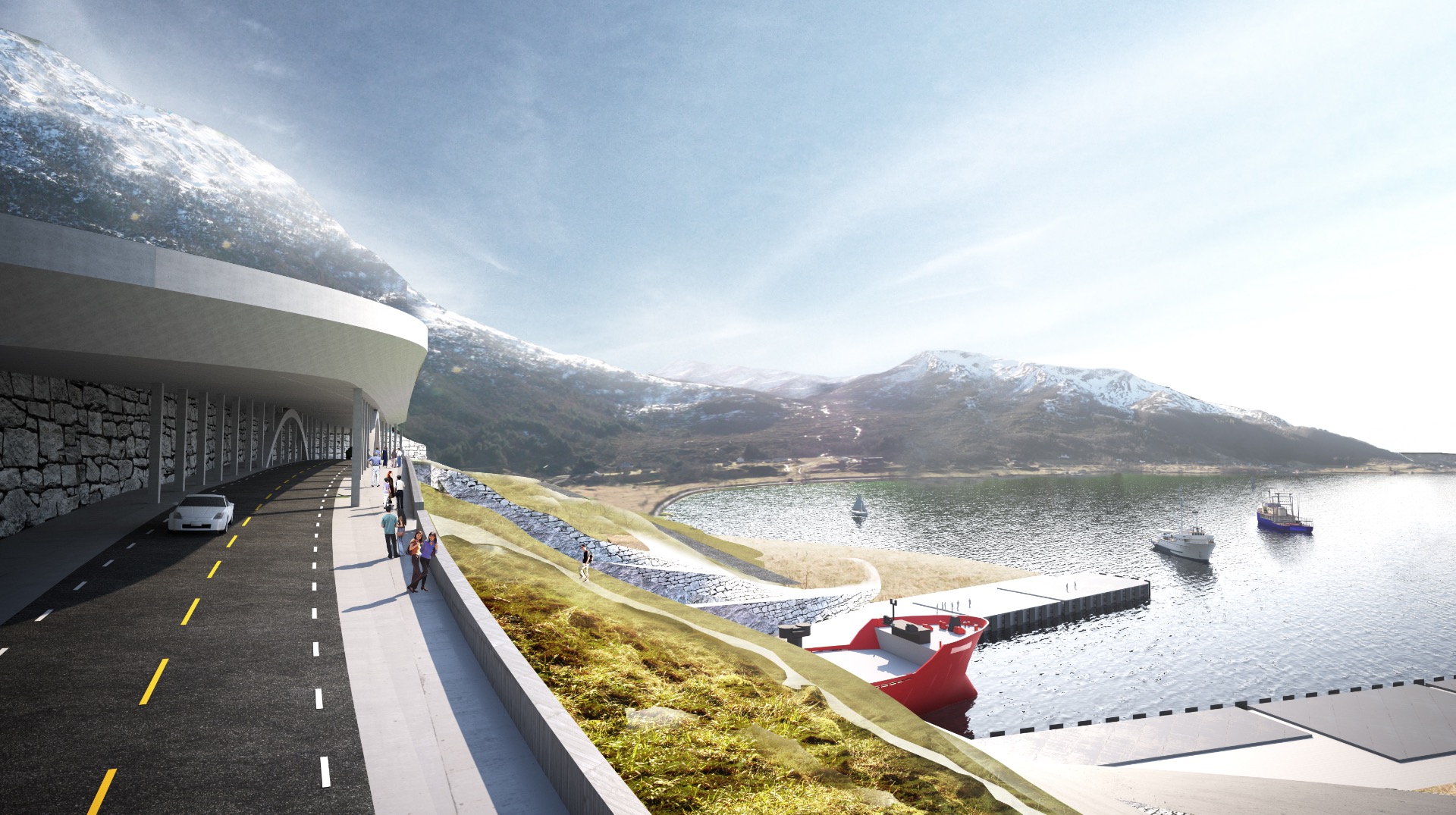
notfried7 hours ago
When an architecture company seemingly uses AI to render mockups, they really need to ensure consistency and accuracy. It's not that difficult nowadays. It was quite confusing trying to understand the differences in design between pictures and to compute why the tunnel seems so short compared to the mountain, until I realized it must have been laziness; not laziness because they are using AI, but laziness to do their job right.
bborud3 hours ago
Of course, the tunnel will be in non-euclidian space. So it is shorter on the inside than on the outside :-)
StevenWaterman7 hours ago
I'd be very surprised if this was AI, it's too bad-looking. The lighting is all wrong, there's noticeable repeating rock textures
eesmith6 hours ago
And they've been around for years.
You can see a copy of that last image (3rd in the gallery) from 2017 at https://web.archive.org/web/20170707052808/https://www.ship-... and at https://newatlas.com/stad-ship-tunnel-interview-terje-andrea... .
A copy of the first image in the gallery is at https://dozr.com/blog/stad-ship-tunnel dated 2021.
Edit: ahhh, 2017 and 2021 were the previous two big announcements about the tunnel. See my notes at https://news.ycombinator.com/item?id=48597546 .
pixl974 hours ago
Heh, it's kind of funny to see how many things are called AI that aren't AI, remember that when we see discussions in HN saying articles are AI or replies are AI.
It's memeable in many cases.
P1 "AI pictures are bad"
P2 "But AI was trained on human pictures"
[Human picture]
black_knight3 hours ago
Soon enough thought, the AI will learn this too from us and we will have AI bots writing comments about how TFA is AI generated.
bondarchuk7 hours ago
Yeah it looks more like photocollage creatively photoshopped. Perspective is very weird in picture 3 too, very cubist.
wongarsu6 hours ago
I suspect quickly slapped together 3d renders photoshopped into actual landscape images. With very limited attention to detail when it comes to matching perspective or lighting between render and photo, or when it comes to blending them together
There are more images like [1] that are just the cheap 3d renders, with less of the photoshop butchery
https://newatlas-brightspot.s3.amazonaws.com/archive/snohett...
duskdozer6 hours ago
I can't see TFA due to cloudflare, but there is a unique image style used in a lot of architectural mockups of proposed buildings and things that also looks very strange and uncanny. I can't find any examples of it online right now unfortunately, but could that be what they're doing?
[deleted]an hour agocollapsed
tokai6 hours ago
I don't see anything in those visualizations that makes me think AI. Its completely run-of-the-mill architect visualizations that have always been atrocious.
thrance6 hours ago
> not laziness because they are using AI, but laziness to do their job right.
It correlates often enough.
eesmith6 hours ago
Previous HN postings which had comments are:
"A plan to build a ship tunnel" (2017), at http://newatlas.com/stad-ship-tunnel-interview-terje-andreas... with 29 comments at https://news.ycombinator.com/item?id=13920841
"First ship tunnel to be built under Norwegian mountains" (2021), at https://edition.cnn.com/travel/article/norway-ship-tunnel/in... with 25 comments at https://news.ycombinator.com/item?id=26540805
See also gCaptain at https://gcaptain.com/worlds-first-ship-tunnel-to-bypass-dang... from 2017 and https://gcaptain.com/norway-gives-green-light-for-worlds-fir... from 2021.
philipwhiuk5 hours ago
I'm not hugely sure I see the point - it doesn't link to anywhere major. Is Måløy to Åheim a major route?
abujazar4 hours ago
It's the main lane where all coastal traffic passes, and one of the most dangerous and weather sensitive regions on the lane. Larger ships sail farther out when weather conditions don't allow for sailing the coast, but a lot of traffic including fishing vessels carrying fresh fish simply have to wait. So it's not as meaningless as geography makes it look.
rob744 hours ago
Not this specific route, but it would be very useful for the Hurtigruten ships that serve the entire Norwegian coast (mentioned in the Wikipedia article, actually the ship shown in the tunnel cross-section has the Hurtigruten livery: https://en.wikipedia.org/wiki/Stad_Ship_Tunnel).
em-bee3 hours ago
as i understand it, the problem is not getting to Åheim, but sailing along the coast, where, in this part, the conditions are frequently bad. the tunnel is not a shortcut to Åheim but a detour passing Åheim to avoid the coastal area and instead sail through the fjords.
tuwtuwtuwtuw5 hours ago
From Wikipedia:
> The Stad Ship Tunnel (Norwegian: Stad skipstunnel) is a planned canal and tunnel to bypass the Stad peninsula in Stad Municipality in Vestland county, Norway. The peninsula is one of the most exposed areas on the coast, without any outlying islands to protect it from the weather. The section has traditionally been one of the most dangerous along the coast of Norway.
> The surrounding waters, known as the Stadhavet Sea, is the most windswept part of the nation's coastline and is stormy around 100 days of the year, leading to ships often waiting days to pass through.[6][7] Currents, created by the area marking the meeting point of the North Sea and the Norwegian Sea further complicate navigation: Since World War Two ended, 33 deaths have occurred in maritime accidents within the Stadhavet Sea.[5] The official Visit Norway website has claimed Vikings would drag their boats over the peninsula to avoid crossing the dangerous patch of sea.
VorpalWay4 hours ago
"Stadhavet Sea", since havet means "the sea" (in both Swedish and (as far as I know) Norwegian), that is a terrible phrasing on English Wikipedia. It should be either just "Stadhavet" or "the Stad sea".
Though, to be fair, there are a lot of places with silly names like that. From what I have heard "Sahara Desert" translates to "Desert desert" for example. I seem to remember there is even a place that translates as "hill hill hill" somewhere in UK, using three different languages.
vidarh4 hours ago
> I seem to remember there is even a place that translates as "hill hill hill" somewhere in UK, using three different languages.
You might be thinking of Torpenhow. It's not clear the etymology actually supports the "hill hill hill" (I thought it did). But there are enough silly names like that for a Wikipedia list:
https://en.wikipedia.org/wiki/List_of_tautological_place_nam...
Quite a few of the English ones are incidentally down to either Norse or Germanic influence. E.g. most island names ending in "-ey" (compare -øy) that has gotten "island" added, like Canvey island.
kitd2 hours ago
"Pleonasm" is the word you're looking for:
borosuxks3 hours ago
Norway had Nesoddtangen, which is three versions of the english point or head (nes, odde, tange) put together
vidarh2 hours ago
I really should have remembered that - we occasionally went via Nesoddtangen to get to my grandparents cabin. I took the ferry there just last summer.
[deleted]7 hours agocollapsed